Live Traffic regions
Greater Sydney
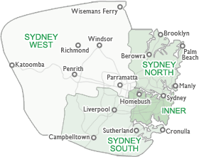
Sydney – Inner
Starts from the Sydney Harbour Bridge and extends to Alfords Point and Taren Point Bridges in the south. It covers the Sydney CBD, and the eastern suburbs of Watsons Bay to La Perouse. It also covers the inner western suburbs bounded by Lidcombe and Strathfield.
Sydney - South
Bounded by Liverpool and Sylvania to the north to Waterfall and Appin to the south. It extends from Kurnell and the Royal National Park in the east to Warragamba and Picton in the west.
Sydney - North
Starts from the Sydney Harbour Bridge and extends north to the Hawkesbury River Bridge at Brooklyn. It includes the Northern Beaches suburbs of Manly to Palm Beach. In the north west the region is bounded by Castle Hill and Ryde.
Sydney - West
Covers Bankstown, Auburn and Parramatta and stretches as far west as the lower Blue Mountains, including Katoomba and Mulgoa. It is bounded by Sackville and the Wollami National Park in the north west and extends as far south as Cabramatta.
Regional and rural NSW
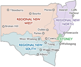
Regional NSW - North
Starts north of the Hawkesbury River Bridge at Brooklyn and extends as far north as Tweed Heads and the Queensland border. It covers the Central Coast and extends to Wisemans Ferry in the south. The area is bounded by Gunnedah and Merriwa in the west and includes the towns of Grafton, Armidale and Tamworth.
Regional NSW - West
Bounded by Broken Hill and the South Australian border to the west to Mudgee and the Blue Mountains in the east. This region extends as far north as Tibooburra and the Queensland border and as far south as Cowra and Marsden. The region includes the towns of Dubbo, Parkes and Bourke.
Regional NSW - South
Bounded by the South Australian border and Wentworth in the west to Bega and Batemans Bay in the east. The region extends as far south as Deniliquin and the Victorian border and as far north as Helensburgh and Abercrombie. The region includes the towns of Griffith, Young and Wollongong.